CI‑110 Plant Canopy Imager vs Drone‑Based LAI Measurements: Which gives you more for your money?

Scott Trimble
November 18, 2025 at 6:53 pm | Updated April 14, 2026 at 3:23 am | 5 min read
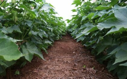
A plant canopy imager has become a core tool for crop scientists who want quick, reliable leaf area index (LAI) measurements in the field. Many research teams now debate whether handheld canopy instruments or drone-based LAI models offer better value. Both approaches collect important canopy structure data, but they differ in cost, accuracy, workflow, and the type of insights they provide.
This article breaks down how the CI-110 Plant Canopy Imager compares with drone-based LAI measurements so you can decide what delivers the most return for your research budget.
What the CI-110 Plant Canopy Imager Offers
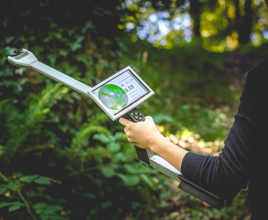
The CI-110 captures hemispherical canopy photos with a self-leveling digital camera and calculates LAI and other canopy parameters directly in the field. It measures photosynthetically active radiation (PAR) using 24 photodiodes and processes gap fraction, leaf angle distribution, extinction coefficients, and sunflecks.
Subscribe to receive our monthly round-up of articles.
Key capabilities include:
-
150 degree field-of-view hemispherical image
-
Instant LAI calculation from images or PAR sensors
-
Built-in 7 inch capacitive touchscreen
-
Internal GPS, Glonass, Beidou, and Galileo for accurate location data
-
Neutral density filters for optimizing image quality under varying light conditions
-
Image and data visibility in the field
-
Works under any sky condition
The CI-110 serves as a portable field tool that provides results immediately, without relying on aerial data capture or post-processing time back in the lab.
What Drone-Based LAI Measurements Offer
Drone-based systems estimate LAI using multispectral, RGB, or LiDAR sensors mounted on UAVs. These platforms generate canopy models or vegetation indices such as NDVI that correlate with LAI. The value lies in covering large areas quickly and capturing field-scale variation that a researcher may miss on the ground.
Typical drone-based LAI workflows involve:
-
UAV flight planning and battery management
-
Sensor calibration before each flight
-
Collection of georeferenced images
-
Uploading imagery into processing software
-
Running 3D canopy reconstruction or vegetation index algorithms
-
Exporting LAI estimates, maps, or point clouds
This approach requires hardware, trained operators, regulatory permissions in some countries, and computer processing time.
Accuracy and Reliability in LAI Data
CI-110 Accuracy
The CI-110 uses hemispherical photography supported by PAR sensors, providing direct LAI calculations instead of indirect estimation. Because the instrument applies user-selectable thresholding methods such as the Otsu Method and Entropy Crossover Technique, it reduces classification errors that often occur with poor lighting or contrast.
Researchers benefit from:
-
Controlled and repeatable imaging conditions
-
Stable, self-leveling camera positioning
-
Immediate feedback in the field
These advantages help avoid the most common errors in manual canopy photography.
Drone LAI Accuracy
Drone-based LAI depends on indirect estimation. Vegetation indices may correlate with LAI but often require calibration plots, ground truthing, and species-specific adjustments. Canopy shadow, light angle, sensor noise, and reconstruction errors can influence results.
For studies that need precise LAI values rather than broad canopy patterns, calibration becomes essential. This adds time and complexity, especially when multiple crop types or growth stages are involved.
Field Workflow and Time Efficiency
CI-110 Workflow
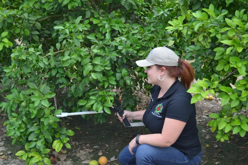
A plant canopy imager like the CI-110 requires almost no setup. Turn it on, let the camera self-level, choose image or PAR mode, and record LAI. Each measurement takes fractions of a second.
Researchers can:
-
Walk through plots
-
Capture images at each sampling point
-
Store or export results later
The workflow suits breeding plots, nutrient trials, irrigation studies, or any setup where regular canopy monitoring is necessary.
Drone Workflow
Drone workflows involve:
-
Hardware transport
-
Battery charging
-
Mission planning
-
Sensor calibration
-
Flying time
-
Processing time
-
Quality control
Although the drone covers large areas faster than a researcher walking through plots, the extended preparation and processing stages often take more time overall. For small to mid-scale studies, drones may create more overhead than benefit.
Cost and Return on Investment
CI-110 Cost Considerations
A plant canopy imager is a one-time equipment purchase with minimal ongoing expenses. There are no flight permissions, no service contracts for UAVs, and no need to upgrade computers for image reconstruction. The CI-110 only needs routine handling and the occasional firmware update.
The durability and portability allow shared use across teams, reducing per-user cost.
Drone Cost Considerations
Drone-based LAI requires:
-
A UAV platform
-
Sensors
-
Spare batteries
-
Licensing or regulatory fees (depending on region)
-
Software subscriptions for photogrammetry or vegetation analysis
-
Maintenance and repairs
These costs scale quickly, and the system becomes expensive if you do not fly regularly. For many research groups, the ongoing cost of ownership outweighs the benefits unless they already use drones for other measurements such as mapping, stand counts, or thermal imaging.
Data Depth and Type of Information
CI-110 Data
The CI-110 provides:
-
LAI
-
Gap fraction
-
Leaf angle distribution
-
Canopy extinction coefficients
-
Sunfleck analysis
These metrics help researchers interpret canopy structure, light interception, and photosynthetic potential without extra processing.
Drone Data
Drones excel in:
-
Large area mapping
-
Spatial pattern detection
-
Multi-plot comparisons
They show where canopy differences exist but often do not provide the physiological structure measurements the CI-110 delivers.
When detailed canopy architecture matters, the plant canopy imager gives more depth per measurement.
Light Conditions and Measurement Consistency
The CI-110 is designed to measure under any sky condition. The system includes neutral density filters and thresholding methods that stabilize image quality even in highly variable conditions.
Drone-based systems struggle under:
-
Harsh shadows
-
Thin clouds
-
Rapid light shifts
-
Low solar angles
These factors influence reflectance and vegetation indices, reducing reliability unless flights are carefully timed.
When the CI-110 Plant Canopy Imager Delivers More Value
The CI-110 outperforms drone-based LAI in several research contexts:
-
Repeated LAI monitoring at consistent points
-
Detailed canopy architecture analysis
-
Small and mid-scale experimental plots
-
Situations with limited budgets
-
Studies needing instant results in the field
-
Research groups without UAV flight resources
Drones shine when you need field-wide spatial pattern mapping, but many crop science and ecology projects prioritize high-quality point measurements instead.
Final Recommendation
If your work depends on detailed LAI measurements, fast field workflow, low cost of operation, and consistent data quality, the CI-110 plant canopy imager gives you more value for your money. Drone-based LAI adds scale but brings higher cost, more complexity, and less direct accuracy without extensive calibration.
For most research teams, the CI-110 provides the strongest balance of simplicity, reliability, and scientific depth.
FAQs
1. Can the CI-110 replace drone LAI for large fields?
The CI-110 can handle grid sampling across large fields, but drones still offer faster whole-field mapping. It depends on whether you need spatial patterns or precise point-based canopy measurements.
2. How does the CI-110 handle bright sunlight or harsh shadows?
It includes neutral density filters and thresholding tools to maintain image quality in variable light conditions.
3. Do drone systems provide leaf angle or gap fraction data?
Most drone workflows do not provide these metrics directly. The CI-110 does, which is why it gives deeper canopy structure insight per measurement.
Related Products
Most Popular Articles
- Transpiration in Plants: Its Importance and Applications
- Leaf Area – How & Why Measuring Leaf Area…
- How to Analyze Photosynthesis in Plants: Methods and Tools
- Plant Respiration: Its Importance and Applications
- The Forest Canopy: Structure, Roles & Measurement
- Stomatal Conductance: Functions, Measurement, and…
- Forest & Plant Canopy Analysis – Tools…
- Root Respiration: Importance and Applications
- 50 Best Universities for Plant Science
- The Importance of Leaf Area Index (LAI) in…