Why is Riparian Canopy Cover important for Water Quality and Wildlife

Dr. Vijayalaxmi Kinhal
March 17, 2025 at 5:13 pm | Updated March 17, 2025 at 5:13 pm | 6 min read
- Riparian zones are the transitional areas between water bodies and uplands.
- Riparian zones provide several ecosystem benefits, such as bank stabilization, water quality and temperature maintenance, lowered downstream flood risks, and wildlife habitat and food.
- Many of the riparian zone benefits depend on a healthy old-growth canopy cover.
Canopy cover and shade of riparian zones vegetation are crucial for adjacent freshwater systems’ hydrology and wildlife. Maintaining a healthy vegetation cover is necessary to protect this unique network as it is productive and has various functions that affect terrestrial and aquatic ecosystems. In this article, you can learn more about the importance of riparian canopy cover.
Riparian Zones
 |
 |
| 1a: Schematic sketch of riparian zone | 1b: Riparian zone in Elbow River watershed |
Figure 1: The riparian zone is a transition area between aquatic and uplands, ERWP. (Image credits: Elbow River Watershed Partnership (ERWP))
A riparian zone is the transitional area between aquatic and upland ecosystems, see Figure 1. The aquatic systems can be waterways (streams and rivers) or water bodies (ponds and lakes).
Subscribe to the CID Bio-Science Weekly article series.
By submitting this form, you are consenting to receive marketing emails from: . You can revoke your consent to receive emails at any time by using the SafeUnsubscribe® link, found at the bottom of every email. Emails are serviced by Constant Contact
The riparian zone includes vegetation from the waters’ edge to uplands. As a transition area from freshwater to uplands, the riparian zone has a distinct species composition and topography from its adjacent ecosystems. A riparian zone is highly complex and has distinct soil, physical, and biological characteristics that form a system together, and any missing component can hinder its proper functioning. The significant factors of a riparian zone are topography, soil conditions, vegetation, and wildlife.
Riparian zones can vary in size depending on the type of water body, topography, hydrological conditions like floodplains, and surface and groundwater availability. Riparian zones are also influenced by spatial and temporal factors at many scales. The spatial factors can be the uplands or the aquatic system, and temporal factors can be seasonal fluctuations in water in the aquatic body or leaf fall in autumn.
Nowadays, riparian zones can also be artificially created by restoration projects to mitigate previous human activities that destroyed natural riparian ecosystems. Riparian zones are one of the most productive and species-rich environments, providing several ecosystem benefits due to their various functions.
Functions of Riparian Zones

Figure 2: Functions of the various components in riparian zones, Manitoba. (Image credits: https://www.gov.mb.ca/mr/land_use_dev/pubs/riparian_area_guide.pdf)
Riparian zones have many functions that affect the aquatic and terrestrial ecosystems next to them.
Stabilizes banks and water flow
Riparian zones have unique vegetation species that can survive in these alternate dry and wet zones. Their root systems are deep and bind soil to protect it from erosion by the water body and stabilize banks. The roots hold the shorelines and can be crucial for people to avoid losing property and buildings near the banks.
Wood debris-like logs that fall into the water also stabilize the banks and control sediment and gravel movement. The wooden debris can also slow water speed in streams.
Slows water runoff
Vegetation of all kinds- grasses, shrubs, and trees absorb rainwater and transpire to reduce runoff. Tree canopy cover breaks the impact of rainfall and slows water runoff on the slope. Shrubs and grasses also reduce the speed of water runoff and soil erosion. Together, the vegetation lowers flow into water bodies, reducing flooding risks during heavy rainfall.
Slowing runoff allows more water percolation into the soil to replenish groundwater supplies, which can be crucial for stream systems. The headwater or first- to second-order streams of rivers are recharged by groundwater discharge and can be intermittent or perennial. Hence, well-developed vegetation in the riparian zones is essential for maintaining water flow and quality in streams and rivers.
Maintains water quality
The increased percolation into the soil through riparian vegetation maintains water quality in many ways.
- It prevents soil erosion that can wash into the water as sediment.
- The riparian vegetation filters nutrients and pollutants mechanically and biologically from the runoff to improve water quality before it enters the water body.
Riparian zones bordering first to fourth-order streams that account for 90% of a stream network are crucial for maintaining water quality.
Provides shade and cooling
The canopy of riparian shrubs and trees covering the water surface provides shade and cools the water temperature. The lower water temperatures reduce water evaporation. Moreover, cooler waters have more dissolved oxygen and favor many aquatic species.
Provides habitat and food
Riparian zones provide habitat and food for aquatic and terrestrial animal species.
- Habitat: The shade of trees, shrubs, and wooden debris provide living and breeding niches and protection from predation for many aquatic species. The shade along the banks also increases the number of living and breeding places for animals.
- Food: Organic matter and leaves from riparian vegetation that enter the water are crucial nutrient inputs for the aquatic system. The organic matter is broken down and consumed by invertebrates, food for higher tropic levels, like fish, birds, and mammals.
Supports biodiversity
Riparian zones increase biodiversity at local and larger scales in many ways.
- Transition zones: As transition zones, they support vegetation and animal species not seen in aquatic and uplands.
- Provide habitats: the riparian zones increase habitat and provide food for many species.
- Varying composition: The shoreline can have riparian vegetation of varying ages and species composition, providing habitats for different wildlife.
When riparian zones are absent or are severely degraded, it can result in shoreline land loss, soil erosion, pollution and eutrophication of water bodies, a decrease in groundwater aquifers, a reduction in wildlife and fish, and increased water treatment costs.
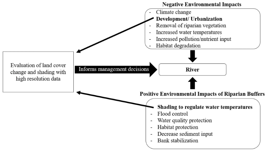
Figure 3: “An evaluation of shading and land cover establishes a framework for monitoring riparian buffers to protect against negative impacts on river systems,” Bolick et al. 2021. (Image credits: https://www.mdpi.com/2072-4292/13/20/4172)
Canopy Cover Importance
The species composition of vegetation along water bodies varies depending on area, topography, elevation, soils, and climate. Also, the age of the vegetation alters canopy structure and biomass and will vary between early succession stages and well-established forests.
The role of forest canopy cover and shade in riparian zones has only received attention for around 15 years. Climate change effects such as increased air temperatures, tree pests and diseases, and extreme weather events have affected species composition and canopy cover denseness in riparian zones. A healthy riparian zone with well-established vegetation can buffer the effects of rising river water temperatures and incidents of heavy rainfall. A riparian canopy cover within five meters of the bank can reduce river temperature, runoff, and floods and maintain water quality. In contrast, removing riparian tree cover within 10 meters of the bank can have adverse effects.
Studies show that early successional forests in riparian restoration projects have closed canopy cover and more shade. In comparison, old forests with canopy gaps have spatial variation in their canopy closure. As a result, old forests let in variable direct light and sun flecks to the streams, creating a mosaic of shade and light that is better for riparian and aquatic systems. Variations in light and shade will also vary diurnally, seasonally, and over decades. Hence, tree canopy structure’s presence/ absence and complexity are essential in determining water temperature and quality.
Old-growth or late-successional forests are also more optimum as they have the necessary three-dimensional complexity of canopy structure and enough biomass to produce wood debris and organic matter input for the aquatic bodies adjacent to it.
Recently, efforts have been underway in the US to restore degraded riparian zones of first- and second-order streams. The secondary buffer forests must develop the qualities of old growth to maintain required fluvial and hydrology, sediment, and nutrient dynamics; also see Figure 3.
Monitoring Riparian Canopy Cover
Riparian tree cover is evaluated in restoration projects using aerial and satellite imagery. Research studies can use the CI-110 Plant Canopy Imager to estimate canopy closure and light percolation to guide these projects. The instrument acquires images through the 150o viewing fish-eye camera and measures sun flecks and solar radiation through 24 photodiodes. GPS access to four satellites allows precise location mapping of data points, and analysis results can be obtained in real time. Research in the relatively unexplored field of riparian canopy cover can advise efforts and funds aimed at maintaining riparian zones for their numerous ecosystem benefits.
Learn more about the CI-110 Plant Canopy Imager and services provided by CID Bio-Science Inc.
Sources
Aadfg.alaska.gov (n.d.). The Role of Riparian Regions. Retrieved by https://www.adfg.alaska.gov/static/fishing/pdfs/sport/byarea/interior/publications/ripariandisplay.pdf
Alberts, J. M., Beaulieu, J. J., & Buffam, I. (2017). Watershed land use and seasonal variation constrain the influence of riparian canopy cover on stream ecosystem metabolism. Ecosystems, 20, 553-567.
Bolick, M.M., Post, C.J., Mikhailova, E.A., Zurqani, H.A., Grunwald, A.P., & Saldo, E.A. (2021). Evaluation of Riparian Tree Cover and Shading in the Chauga River Watershed Using LiDAR and Deep Learning Land Cover Classification. Remote Sens. 13, 4172. https://doi.org/10.3390/rs13204172
Elmore, W., and Beschta, R. L. (1987). Riparian Areas: Perceptions in Management. Rangelands 9(6),. Retrieved from 10967-23018-3-PB.pdf
Kelley, C. E., & Krueger, W. C. (2005). Canopy cover and shade determinations in riparian zones 1. JAWRA Journal of the American Water Resources Association, 41(1), 37-046. DOI:10.1111/j.1752-1688.2005.tb03715.x
Mantibo. (n.d.). Planning Resource Guide Planning for the Protection of Riparian Areas. Retrieved from https://www.gov.mb.ca/mr/land_use_dev/pubs/riparian_area_guide.pdf
Rheinhardt, R. D., McKenney‐Easterling, M., Brinson, M. M., Masina‐Rubbo, J., Brooks, R. P., Whigham, D. F., … & Armstrong, B. K. (2009). Canopy composition and forest structure provide restoration targets for low‐order riparian ecosystems. Restoration Ecology, 17(1), 51-59.
Shannon, P.D., Swanston, C.W., Janowiak, M.K., et al. (n.d.). Adaptation Strategies and Approaches for Forested Watersheds. Retrieved from https://www.climatehubs.usda.gov/approach/maintain-or-restore-forest-and-vegetative-cover-riparian-areas
Related Products
Most Popular Articles
- Transpiration in Plants: Its Importance and Applications
- Leaf Area – How & Why Measuring Leaf Area…
- How to Analyze Photosynthesis in Plants: Methods and Tools
- Plant Respiration: Its Importance and Applications
- The Forest Canopy: Structure, Roles & Measurement
- Stomatal Conductance: Functions, Measurement, and…
- Forest & Plant Canopy Analysis – Tools…
- Root Respiration: Importance and Applications
- The Importance of Leaf Area Index (LAI) in…
- 50 Best Universities for Plant Science


